UAV Forecast for Drone Pilots
- 4.1
- Rating
- 1.00M
- Installs
- Free
- Price
 Analysis by App-foxy
Before I send a drone into the air, I want more than a general weather symbol. A bright icon saying “partly cloudy” does not tell me whether the wind at flight height is manageable, whether a geomagnetic disturbance could affect a planned session, or whether the area has an aviation restriction worth checking. That is where UAV Forecast earns its place. It is a weather app made specifically for drone pilots, and its most useful idea is simple: it turns a broad forecast into a quick go/no-go check for an unmanned flight.
I tested it with the mindset of someone who would rather cancel a flight early than discover a problem after takeoff. The app comes from Good To Forecast and is available free of charge, with optional in-app purchases ranging from $1.99 to $119.99 per item. It is rated for Everyone, runs on Android 7.0 and later, and its current version is 2.9.40. The app has passed one million installs, with an average rating of 3.9 from around seventeen thousand ratings and about one and a half thousand written reviews.
Those figures suggest a useful but not universally loved tool, which matches my impression. This is not the weather app I would open to decide whether to carry an umbrella to work. It is more focused than that. Its value appears when I need to judge conditions for a drone, particularly when the ordinary forecast feels too vague for a piece of equipment that can be affected by wind, visibility, airspace restrictions, and changing conditions.
You May Also Like

 Blood Strike: 2.5 Anniversary
Blood Strike’s Loadouts Turn Every Drop Into a Tactical Gamble
A close look at Blood Strike’s custom loadouts: how fast access to signature weapons reshapes its battle royale rhythm, rewards preparation, and narrows the gap between fights.

 Pandora - Music & Podcasts
Pandora’s Music Is Easy to Start, but Harder to Recover
Pandora’s strength is its low-effort path from a seed to a station. Its weak spot is how much confidence it asks you to place in connection, setup, and quiet recovery.

 8 Ball Pool
 Is Built on Rivalries, Rematches, and Routine
A close look at the rivalries, rematches, shared routines, and unanswered safety questions that turn a quick pool match into a persistent mobile community.

 Samsung Music
’s Quiet Strength Is Playing What You Already Own
Its reach comes less from spectacle than from dependable access to a personal library. That simplicity is both the app’s strongest retention engine and its ceiling.

 AccuWeather: Weather Radar
AccuWeather Review: A Quick, Clear Forecast for Everyday Decisions
For everyday plans, the best forecast is the one you can understand quickly. AccuWeather makes rain timing, radar, and local conditions easy to act on, with a few trade-offs.

 Hill Climb Racing
Why Hill Climb Racing Still Turns Crashes Into One More Run
A tiny car, a bumpy hill and one more upgrade: Hill Climb Racing keeps resurfacing because its simple chaos makes every near-miss feel personal.
More From Our News Desk



A weather check built around the flight, not the picnic
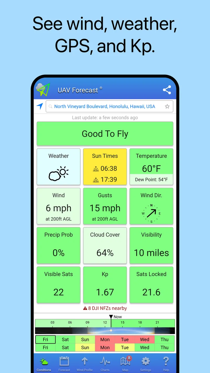
The central capability is the app’s pilot-oriented forecast view. Instead of making me translate a standard weather report into drone terms, it places information such as winds aloft, GPS-related conditions, the Kp index, No-Fly Zones, and TFRs close to the decision I am trying to make. That focus changes how I read the forecast. I am not simply asking, “Will it rain?” I am asking, “Does this location look sensible for the aircraft and the type of flight I have in mind?”
The important difference is decision support rather than decoration. A typical weather app may show current wind at ground level and a general hourly outlook. That can be enough for walking, driving, or planning a day outdoors, but a drone pilot needs to think about what happens after the aircraft climbs. Wind higher above the ground may not feel obvious from the launch point. UAV Forecast brings that concern into the main view instead of leaving me to search through several weather layers.
I also like that the app treats airspace awareness as part of the preparation process. The inclusion of No-Fly Zones and TFRs does not make the app a substitute for official aviation information or local rules, but it gives me a reason to pause before I start the motors. That is a practical improvement over checking a normal forecast and assuming suitable weather means a suitable flight.
The Kp index is another example of the app’s specialist angle. It is not a detail most casual weather users need during a normal day, yet it makes sense in a drone workflow because satellite navigation and flight confidence matter more when the aircraft is away from me. I do not treat one indicator as an automatic cancellation command, but seeing it alongside the rest of the forecast helps me avoid relying on a single reassuring number.
Reading the screen as a go-or-no-go routine
In practice, I would open the app at the location where I expect to launch, review the current conditions, and then look ahead rather than stopping at the first favorable line. The useful habit is to compare the forecast with the actual flight plan. A short, low flight near the launch point is not the same as a longer trip over open ground. The app can show the conditions, but I still have to interpret them according to the aircraft, the route, and my experience.
That distinction matters because a forecast can be technically favorable while the flight is still a poor idea. A wind value may look acceptable for a lightweight drone but less comfortable for a larger camera platform. A clear sky does not remove the need to check restricted areas. A calm launch site may not represent conditions higher up. The app is strongest when I use it as a structured checklist rather than as permission to fly.
One of my favorite practical uses is checking the forecast twice: once before leaving home and again at the launch location. The first check prevents a wasted trip. The second catches a changed situation and encourages me to compare the displayed conditions with what I can actually see and feel. If the forecast and the environment disagree, I would trust caution, postpone the flight, or investigate further rather than forcing the plan to fit the screen.
The location-focused approach also makes the app more useful for pilots who visit several launch areas. Instead of keeping a mental note that one field is usually calm and another is usually exposed, I can use the same forecast process for each place. That does not eliminate local knowledge, but it gives local knowledge a current weather reference.
Why winds aloft are the feature I would use most
For me, winds aloft are the capability that gives this app its clearest advantage over an ordinary weather application. Ground-level conditions can be misleading, especially when the launch area is sheltered by trees, buildings, or a slope. Once the drone rises, it may encounter a different airflow. That can affect battery use, stability, return travel, and how comfortable I feel flying farther from the controller.
The practical lesson is not simply “more wind is bad.” Direction matters, the aircraft matters, and the route matters. A flight that goes out with the wind may need to return against it. A drone that handles a brief hover comfortably may use more energy when it spends several minutes moving into a headwind. Looking at the upper-air forecast before takeoff encourages me to plan around those differences instead of discovering them while the drone is already away.
This is also where the app can help newer pilots build better judgment. Someone who only watches the trees at the launch point may assume the air is calm. Seeing a different picture at flight height creates a useful mental model: the atmosphere is not one flat layer, and a drone experiences more than the weather I feel standing on the ground.
I would still avoid treating the displayed wind information as a precise promise. Forecasts change, conditions vary across a location, and gusts can be more important than a smooth average. The app improves my preparation, but it does not replace observing the area, knowing the aircraft’s limits, or leaving enough battery margin for an early return.
The best everyday scenario for UAV Forecast
Imagine I have planned a short landscape flight after work. The sky looks promising, but I have only a limited window before sunset and do not want to drive to the location blindly. I open the app at home and check the selected launch area. The general forecast may look fine, yet the winds aloft show that the air higher up is less comfortable than the ground conditions suggest. I can change the plan before packing the drone, choose a more sheltered site, shorten the route, or wait for a better period.
At the location, I check again. This time the wind feels stronger than expected and the forecast indicates conditions that make the planned route less attractive. Rather than launching because I have already made the trip, I can treat the app as a prompt to reconsider. That is a small workflow change, but it is exactly the kind of change that can protect equipment and reduce rushed decisions.
For a recreational pilot, this is probably the most realistic benefit: fewer casual launches based only on a pleasant-looking sky. For a photographer, the app is useful before committing to a remote viewpoint. For someone learning to fly, it provides a repeatable preparation routine. For a pilot who often works near changing airspace conditions, the No-Fly Zone and TFR information adds another reason to check the screen before takeoff.
I would not use it as the only source for a formal operation. A professional or highly regulated flight may require official aviation sources, local authority information, and a more complete risk assessment. The app can sit at the beginning of that process, helping me identify weather or airspace questions, but it should not be the final authority when the consequences of an incorrect decision are serious.
How the specialist details change the way I plan
The app’s strongest effect is psychological as much as technical: it slows me down. A normal weather app can make a flight feel ready because the forecast is presented for general comfort. UAV Forecast asks me to consider the aircraft’s environment. I start thinking about altitude, return direction, navigation confidence, and restricted airspace before I even open the drone controller.
That makes it particularly helpful for flights that seem easy but contain hidden variables. A short flight across an open field may expose the drone to more wind than a sheltered backyard. A location that is visually perfect for a photograph may be close to a restriction. A calm morning may not remain calm during the entire time I expect to be outside. The app cannot solve those issues, but it makes them harder to overlook.
A useful advanced habit is to use the forecast to define limits before arriving. For example, I can decide that I will keep the route short if the wind direction makes the return leg uncomfortable, or that I will cancel if the airspace layer raises a question I cannot resolve. Making that decision in advance is better than negotiating with myself after the drone is airborne.
I also find value in comparing the forecast with the aircraft’s behavior over time. If the drone consistently feels more affected than the screen led me to expect, that experience should change how I interpret future forecasts. No app knows my exact comfort level, battery condition, payload, or route. The best results come from combining its information with a personal record of what different conditions feel like in real flights.
Where the app can create friction
The specialist focus is also its main limitation. If I only want a simple temperature forecast, rain chance, or pleasant daily overview, this app may feel more complicated than necessary. Its aviation-oriented information asks for interpretation, and a new pilot may not immediately know which indicator should carry the most weight. The app is more useful after I understand why each item matters.
The 3.9 average rating reflects a fairly mixed reception rather than universal approval. I can understand that. A focused tool can be valuable to one pilot and excessive to another. People who expect the polished simplicity of a mainstream weather app may find the extra aviation details less approachable. The free entry point is helpful, but optional purchases can also make users wonder which parts of the experience are included and which require payment before they settle into a routine.
Another limitation is that no forecast should be mistaken for live certainty. Wind can change between checks, local terrain can distort conditions, and a map indication deserves verification when it affects a real flight. I would especially avoid launching solely because the app looks favorable if visibility is poor, the site is crowded, the aircraft has a technical issue, or I have not confirmed the applicable local rules.
The app also cannot replace a proper flight plan. It can support the weather and situational-awareness portion, but it does not remove the pilot’s responsibility to maintain control, preserve a safe return option, respect people and property, and follow the rules that apply to the location. That boundary is important: UAV Forecast helps me prepare; it does not make the decision for me.
Who should choose it over a normal weather app?
I would recommend it most strongly to drone owners who regularly fly outdoors and want a repeatable preflight check. It is especially suitable for pilots who have already experienced the difference between calm ground conditions and uncomfortable air above them. The winds-aloft view alone can justify keeping a specialist tool available, because it addresses a question that general weather apps often leave buried or unanswered.
It is also a good fit for cautious beginners, provided they are willing to learn what the indicators mean. The app gives them a reason to think beyond temperature and rain. Used properly, it can encourage better habits: check before leaving, check again at the site, compare the forecast with reality, and keep a conservative plan when conditions are uncertain.
Traveling pilots may appreciate the location-based approach as well. When I visit an unfamiliar area, I do not have the same intuition about wind exposure or local conditions that I have near home. A focused weather screen gives me a starting point for research. I would still confirm restrictions through appropriate official channels, but the app helps identify the questions I need to ask before unpacking the aircraft.
On the other hand, I would skip it if I never fly a drone, if I only need a basic daily forecast, or if I want an app that makes every weather decision automatically. A mainstream weather service is likely more comfortable for ordinary personal planning. A dedicated official aviation source may be the better choice when legal airspace confirmation is the primary requirement. UAV Forecast sits between those extremes: more specialized than a general weather app, but not a complete replacement for formal aviation planning.
My final assessment after using the workflow
UAV Forecast is at its best when the question is “Should I prepare for this flight?” rather than “What will the weather be today?” Its winds-aloft information gives the review a clear center of gravity, while the GPS-related details, Kp index, No-Fly Zones, and TFRs broaden the preflight picture. I value the way those elements encourage a more careful decision before launch, particularly when the ground-level weather looks deceptively friendly.
It is not a magic safety button, and I would not use it alone for a legally sensitive or high-consequence operation. The forecast still needs judgment, local observation, and confirmation from authoritative sources when restrictions matter. The interface may also feel too specialized for people who want a quick, uncomplicated weather glance, and the optional purchase structure is worth considering before committing to a deeper workflow.
Still, for the right person, the free starting point makes it easy to see whether the approach fits. I would keep it installed if I owned a drone and flew often enough for wind at altitude to affect my plans. Good To Forecast has built an app around the details that general weather tools tend to overlook, and that focus gives it a genuine purpose. My recommendation is straightforward: use it as a disciplined preflight companion, not as an automatic green light, and it can make each launch decision more informed and less impulsive.
FAQs for UAV Forecast for Drone Pilots
01What features does UAV Forecast offer for drone pilots?
UAV Forecast provides detailed weather forecasts tailored specifically for drone pilots, including wind speed, temperature, cloud cover, and precipitation. It also offers no-fly zone maps, GPS satellite information, and detailed visibility conditions to ensure safe flying. The app helps users plan flights by providing hourly and daily forecasts that are crucial for safe drone operations.
02Is UAV Forecast available for both Android and iOS devices?
Yes, UAV Forecast is available for both Android and iOS platforms. Users can download the app from the Google Play Store or the Apple App Store. This ensures that drone pilots using different devices can access the same reliable information to plan their flights effectively and safely.
03Does UAV Forecast require a subscription for all its features?
UAV Forecast offers a free version with basic features, but for more advanced capabilities, such as extended weather forecasts and additional map layers, a subscription is required. The paid version provides more comprehensive tools and data, which can be invaluable for professional drone pilots who need detailed planning resources.
04How accurate is the weather data provided by UAV Forecast?
UAV Forecast sources its weather data from reputable meteorological services to provide accurate and up-to-date forecasts. While no forecast can be 100% precise, UAV Forecast is designed to offer highly reliable data specifically tailored for drone flying conditions, helping pilots make informed decisions before taking off.
05Can UAV Forecast help in avoiding restricted flying zones?
Yes, UAV Forecast includes features that display no-fly zones and restricted airspace areas on its maps. This is crucial for ensuring compliance with aviation regulations and avoiding any potential legal issues. The app is regularly updated to reflect changes in airspace restrictions, providing pilots with the latest information needed to remain within safe and legal boundaries.
Pros
- Detailed weather forecasts for flight planning.
- Easy-to-use interface with intuitive navigation.
- Customizable alerts for optimal flying conditions.
- Supports a wide range of drone models.
- Provides no-fly zone notifications for safety.
Cons
- Requires a subscription for advanced features.
- Limited offline functionality.
- Battery usage can be high during operation.
- Some features need stable internet connection.
- Not available for all global regions.

UAV Forecast for Drone Pilots
Gallery